
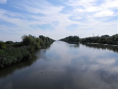
Huntspill River
The Huntspill River was constructed in 1940 as part of the construction of a new Royal Ordnance factory at Puriton. The factory required a guaranteed daily supply water of 4.5 million gallons.The engineer tasked with providing this came up with the idea of combining a storage reservoir with drainage.
A 5 mile channel was cut through the coastal clay belt from Gold Corner to the Parrett estuary. At Gold Corner it was connected to the South Drain. Retention sluices were placed at both ends, thus creating a water storage and drainage system. During summer months the water in the reservoir could be topped up with water from the South Drain via pumping at Gold Corner and during winter months surplus water could be drained into the Parrett Estuary.
he initial design was for a channel depth of 25 feet to allow a gravitational feed from the South Drain. Unfortunately the spoil from the excavations was too heavy for the peat subsoil and pushed the banks back into the channel. A new scheme was devised with a 16 foot deep channel which required water from the South Drain to be pumped into the channel.
A Pumping station was constructed which housed 4 Sultzer horizontal pumps powered by two-cylinder Crossley oil engines. The pumps are still in use today with one being electrified in 1968. The pumps have the ability to pump at the total rate of 1100 gallons per minute.
As a result of the new outlet for the South Drain, the section between Gold Corner and the River Brue was no longer required for drainage. However in 1955 the channel was widened with an additional outlet into the Huntspill River. This together with the construction of Cripp’s sluice at the Brue end enabled a controlled discharge of excess water from the Brue into the Huntspill River. The channel was renamed the Cripps River. Cripp’s sluice as since became redundant.
The Huntspill River is a National Nature Reserve, it discharges, via the Parrett Estuary, into Bridgwater Bay, which is also an important National Nature Reserve, on the edge of the Bristol Channel.
References: The Drainage of the Somerset Levels – Michael Williams and Somerset HER ref:11683
Image Gallery River Map Structures