
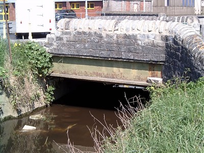
Porchestal Drove bridge
|
|
||||
 |
||||
| Bridge Name: | Porchestal Drove bridge | |||
| No.: | 7 | |||
| Location: | Located at the junction of Dyehouse Lane and Porchestal Drove close to the timber yard. Also known as Benedict Bridge ? Probably the location of Madelode (Middle Lode ) Bridge. | |||
| Build Date: | Late 19th century | |||
| Engineer: | ||||
|
© Copyright somersetrivers.org |
||||
| Description: | ||||
| Single flat arch road bridge with large iron beams and local stone parapets. Carries Porchestal Drove.
Maidlode Bridge (later Benedict Bridge), referred to by 1398, carried traffic from Maidlode Street (later Benedict Street) west onto the moor over the old course of the Brue, which was feeding the millstream, probably replaced a ford in the medieval period, and is marked on the c1609 map1 Although British History online suggests that Madelode Bridge was on the site of the current Cradle Bridge over the canalised section of the River Brue See |
||||
| References: | 1.Somerset Extensive Urban Survey – Glastonbury Archaeological Assessment | |||